Heavy water chargers only · Every piece printed to order

Category: Surf Stories

SHOREY™ surf stories: swell forecasts, heavy-water breaks and shorebreak culture, from the Wedge and Black’s Beach to Australia, the UK and beyond.

  • The Winter of 2026–⁠27: Is a Historic El Niño About to Change Everything?

    The Winter of 2026–⁠27: Is a Historic El Niño About to Change Everything?

    The North Pacific is firing up, a potentially historic El Niño is developing, and Southern California’s winter shorebreak season is approaching. From Seal Beach to the heaviest beach breaks in Orange County, here’s what surfers should be watching.

    SHOREY™ | Surf Culture · Ocean Science · Coastal Stories

    Summer 2026 gave Southern California surfers a season to remember. Powerful South Pacific swells, tropical systems, and extraordinary conditions at Newport Beach’s Wedge put the coastline on full display.

    But now the seasons are changing.

    The South Pacific is giving way to the North Pacific, winter storms are beginning to line up, and one of the strongest El Niño events in modern history is developing across the Pacific.

    For surfers who love heavy shorebreak, powerful wedges, and waves that unload directly onto the sand, winter is when things get interesting.

    And there is one place in particular we’re watching.

    Seal Beach.

    While Newport’s Wedge owns the summer spotlight, Seal Beach has its own winter personality. When the right west-northwest swell meets the harbor structures, jetty, and shifting sandbars, the result can be some seriously powerful Southern California shorebreak.

    This winter, the question isn’t simply whether we’re going to get waves.

    It’s whether the combination of an active North Pacific, a potentially historic El Niño, and favorable local conditions will produce a season we’ll remember for years.

    Let’s look at what’s developing.


    1. A Potentially Historic El Niño Is Developing

    First, let’s talk about the big story.

    El Niño is a climate phenomenon involving unusually warm ocean temperatures across the central and eastern equatorial Pacific. Those temperature changes influence atmospheric circulation and can shift the position of major storm tracks.

    NOAA’s November 12, 2026 climate update confirms that El Niño continues to strengthen.

    The agency forecasts a strong-to-very-strong event through January–March 2027, with approximately a 60% probability of reaching its defined historic threshold for an event exceeding previous El Niños dating back to 1950.

    That’s significant.

    A strong El Niño can influence the position of the Pacific jet stream, increasing the likelihood of storm systems following a more southerly track toward California and the southern United States.

    For California, this can mean increased opportunities for substantial winter precipitation, powerful Pacific storms, elevated coastal water levels, and significant erosion.

    But there’s an important distinction.

    El Niño is not a surf forecast. It doesn’t guarantee larger waves at every beach, nor does it guarantee a constant supply of favorable swell.

    It influences the broader climate pattern. Individual storms determine the actual surf.

    And that’s where the North Pacific comes into the picture.

    2. The North Pacific Storm Machine Is Waking Up

    During summer, Southern California relies heavily on South Pacific swells and tropical systems for its larger waves.

    Winter brings a different source of energy.

    The North Pacific becomes increasingly active as powerful low-pressure systems develop across the northern ocean, particularly around the Gulf of Alaska and the Aleutian region.

    These storms generate enormous seas that can travel thousands of miles toward the West Coast.

    Some systems develop sustained storm-force winds and generate offshore significant wave heights of 40, 45, or even 50 feet.

    These aren’t the heights surfers will necessarily encounter at the beach. They describe the offshore sea state. The actual breaking surf depends on swell direction, period, coastal exposure, and underwater geography.

    Nevertheless, these systems can produce some of the most powerful winter swells of the year.

    Surfline’s November 11 North Pacific outlook described successive major storm systems approaching the Pacific, with offshore seas forecast to reach approximately 45–50 feet.

    That’s the kind of activity that gets our attention.

    The question now is whether this pattern continues throughout the winter and how frequently Southern California receives favorable swell directions.

    Because a massive storm hundreds of miles offshore means very little if its energy doesn’t reach our favorite breaks in the right direction.

    3. Seal Beach: Winter Has Its Own Heavyweight

    For SHOREY™, Seal Beach deserves special attention.

    Located at the northern end of Orange County, Seal Beach has a distinctive coastal configuration involving the San Gabriel River entrance, harbor structures, and surrounding jetties.

    Its different sections respond to different swell directions, making it a particularly interesting location for winter surf.

    The south side of the Seal Beach Pier is especially known for its winter WNW swells.

    When a large west-northwest swell arrives, wave energy interacts with the harbor structures and surrounding coastline.

    The Anaheim Bay west jetty plays an important role in reflecting wave energy toward the beach.

    Under the right conditions, this interaction can produce powerful, steep, wedging waves.

    The City of Seal Beach’s coastal planning documentation describes how reflected winter swell energy can combine with incoming waves, amplifying wave heights along portions of the eastern beach.

    That interaction is part of what makes this coastline so interesting.

    For bodyboarders, skimboarders, and shorebreak enthusiasts, the south side of the pier can become a completely different environment when the right winter swell arrives.

    We’re talking about thick, powerful bowls, steep drops, and waves that break close to the sand.

    But not every winter swell produces those conditions.

    The direction matters. The tide matters. The wind matters.

    Which brings us to something we consider essential.

    4. THE SHOREY™ TRIFECTA: Three Ingredients for the Perfect Session

    Every surfer has experienced it.

    The swell looks incredible, but the wind is blowing the wrong way.

    The wind is perfect, but the tide is too high.

    Or the tide and wind are exactly where we want them, but the swell is coming from the wrong direction.

    At SHOREY™, we call it THE TRIFECTA.

    Three essential ingredients have to come together to create the session we’re looking for.

    1. The Perfect Wind Direction

    Wind can make or break a session.

    The right wind direction helps groom the wave face, creating cleaner conditions, better shape, and more predictable waves.

    At Seal Beach, the local coastline and harbor structures influence how different wind directions affect individual breaks.

    For the south side of the pier, easterly or northeasterly winds are among the favorable conditions identified in the local surf guide.

    2. The Right Tide

    Tide changes the depth of water over sandbars and nearshore formations.

    Some breaks work better on an incoming tide. Others come alive as the water drops.

    At Seal Beach, the mid-tide range is an important starting point for the jetty surf, although the best tide depends on the particular section and how the sandbars are positioned.

    A small change in water depth can dramatically change how a wave breaks.

    3. The Right Swell: Size and Direction

    This is where the magic begins.

    A large swell doesn’t automatically produce good surf.

    The direction determines how the incoming energy interacts with the coastline, while swell size and period influence the power and shape of the breaking wave.

    For the south side of Seal Beach Pier, west-northwest winter swells are particularly important.

    The right combination can create steep, powerful wedges and heavy shorebreak.

    When all three ingredients line up, that’s when the magic happens.

    Perfect wind. Right tide. Right swell.

    That’s THE SHOREY™ TRIFECTA.

    And when the Trifecta comes together, you know where we want to be.

    5. The Science Behind Heavy Winter Shorebreak

    Why do some winter days produce waves that seem to unload directly onto the beach?

    The answer lies in the relationship between wave energy and underwater topography.

    As waves approach shallow water, they begin interacting with the ocean floor.

    Their speed decreases, their height and steepness change, and eventually they become unstable and break.

    The depth and slope of the beach determine how quickly this happens.

    A steep beach profile can cause waves to break abruptly and close to shore, producing the powerful shorebreak conditions that bodyboarders and bodysurfers seek.

    But the underwater landscape is constantly changing.

    Winter storms can transport substantial amounts of sand offshore, creating new sandbars and changing the depth of the nearshore environment.

    These changes can influence:

    • Where waves begin breaking.
    • How steep and hollow the waves become.
    • Whether a peak wedges or closes out.
    • How close waves break to the shoreline.
    • The severity of backwash and reflected energy.

    A familiar beach can look completely different after a few powerful storms.

    That’s part of the appeal of following a beach break throughout the winter.

    You never know exactly what the next swell will reveal.

    6. The Winter Sand Cycle: Is the Beach Going to Recover?

    There is another important part of the story.

    Beaches are constantly gaining, losing, and redistributing sand.

    During calmer summer conditions, many beaches experience a gradual movement of sand back toward the shoreline.

    Offshore sandbars can migrate landward, helping rebuild the beach and create wider, flatter sandy profiles.

    Winter often brings the opposite.

    Powerful storm waves transport sand away from the shoreline toward offshore sandbars and deeper water.

    The beach becomes narrower, the shoreline can become steeper, and underwater formations change.

    This is known as seasonal beach-profile cycling.

    It is important to understand that sand moving offshore does not necessarily mean permanent beach loss.

    Much of it can return during calmer conditions.

    However, repeated powerful storms can move more sand than a beach can recover between events.

    This is where a strong El Niño winter could have a significant impact.

    If powerful storms arrive repeatedly, some beaches may experience erosion that persists well into the following summer.

    For surfers, this isn’t just an environmental issue.

    Sand movement changes the very structure of our surf breaks.

    The sandbar that produced the perfect wedge last month might disappear. A new peak might form farther down the beach. A familiar shorebreak could become steeper and heavier.

    The coastline is constantly being redesigned.

    7. What Could This Mean for Southern California?

    If the developing El Niño and North Pacific storm activity produce an exceptionally active winter, Southern California could experience several important changes.

    More powerful winter storm systems

    A more active storm pattern could bring repeated periods of large surf, heavy rainfall, and elevated coastal water levels.

    Increased coastal erosion

    Large waves combined with high tides and storm surge can move enormous quantities of sand and expose vulnerable sections of coastline.

    Changing sandbars

    Repeated storm events can reshape beaches and alter the location and characteristics of surf breaks.

    More opportunities for heavy shorebreak

    When the right swell direction meets favorable local conditions, exposed Southern California beaches can produce powerful winter waves.

    But there’s no guarantee that every storm will produce favorable surf.

    Some storms will generate large but poorly directed swells. Others will bring strong onshore winds and dangerous conditions.

    The Trifecta remains the objective.

    8. Is This Going to Be a Historic Surf Winter?

    That’s the million-dollar question.

    There are encouraging signs.

    NOAA is forecasting a strong-to-very-strong El Niño through the heart of winter.

    The North Pacific is already generating substantial storm systems.

    Southern California is entering the season with a coastline that has experienced significant changes from the powerful swells of 2026.

    The ingredients are there for an interesting winter.

    But a historic El Niño does not automatically mean a record-breaking surf season.

    To establish that, we’d need to see sustained favorable storm activity, repeated large swells, and the right direction for individual breaks.

    For Seal Beach, the most important thing will be the arrival of strong WNW winter swells, favorable winds, and tides that work with the evolving sandbars.

    The biggest waves won’t necessarily produce the best sessions.

    The best sessions will happen when the Trifecta comes together.

    And that’s what we’ll be watching.

    9. SHOREY™ LOVES WINTER

    Summer has its own personality.

    Newport’s Wedge. South swells. Tropical energy. Warm days and those enormous summer sessions that bring thousands of people to the shoreline.

    But winter is different.

    The North Pacific starts firing. The water gets colder. Storms roll across the ocean. Beaches change. Sandbars move. Familiar breaks develop new personalities.

    And we start watching Seal Beach.

    We love the wedges, the peaks, the barrels, the heavy shorebreak, and those moments when a wave unloads right onto the sand.

    We’re here for the early-morning sessions, the unexpected swell, the perfectly timed double-up, and the days when everything comes together.

    We call it the Trifecta.

    Perfect wind direction. The right tide. The right swell.

    Whether this winter turns out to be historic or simply delivers another memorable season, we’ll be watching the ocean and following the changes along our coastline.

    Because at SHOREY™, it’s never just about how big the waves are.

    It’s about understanding the break, knowing the conditions, and appreciating the power of the ocean.

    SUMMER BELONGS TO THE WEDGE. WINTER BELONGS TO SEAL BEACH. AND SHOREY™ LOVES THEM BOTH.

    The North Pacific is waking up.

    Let’s see what this winter brings.


    SHOREY™

    For the love of waves, shorebreak, and everything in between.

    Respect the ocean. Understand the break. Ride what the ocean gives you.

    Cover photo: byronetmedia on Unsplash
  • El Niño: When the Ocean Takes Back the Beach

    El Niño: When the Ocean Takes Back the Beach

    How winter storms, seasonal sand movement, and powerful Pacific swells reshape our coastlines and transform the surf breaks we ride.

    The ocean is constantly changing the coastline. Every wave, every tide, and every storm contributes to a never-ending process of moving, removing, and redistributing sand.

    For surfers, these changes are more than just a change of scenery. They influence where waves break, how they break, how powerful they become, and whether a familiar surf spot will look anything like it did last season.

    As El Niño develops across the Pacific, the relationship between ocean energy and coastal erosion becomes particularly important. Stronger winter storms, powerful swells, and elevated coastal water levels can dramatically alter beaches, sometimes leaving behind changes that last long after the storms have passed.

    But to understand what El Niño can do to our beaches, we first need to understand something fundamental: beaches naturally gain and lose sand throughout the year.

    1. The Natural Cycle: Beaches Are Always Changing

    One of the biggest misconceptions about coastal erosion is that when a beach loses sand, that sand is gone.

    In many cases, it hasn’t disappeared. It has simply moved.

    Beaches are dynamic environments that constantly exchange sand between the shoreline, offshore sandbars, deeper water, and neighboring stretches of coastline. This process is known as seasonal beach-profile cycling.

    In many parts of California, the natural cycle generally follows a familiar pattern.

    Summer: The Beach Rebuilds

    During summer, wave conditions are often calmer and less energetic than during winter storm season.

    These conditions frequently encourage sand to move from offshore sandbars back toward the shoreline. As sand accumulates, beaches can become wider, flatter, and more inviting.

    This is why some beaches that appear narrow and heavily eroded in winter can look dramatically different by late summer.

    The shoreline is rebuilding itself.

    Winter: The Ocean Moves Sand Offshore

    Winter brings a different set of conditions.

    Powerful Pacific storms generate larger, more energetic waves. These waves can transport substantial quantities of sand away from the shoreline and toward offshore sandbars and deeper water.

    As this happens, beaches can become narrower and steeper. Sandbars shift farther offshore, dunes become exposed, and waves may begin breaking much closer to the beach.

    The beach hasn’t necessarily lost all its sand. Much of it may be temporarily stored offshore.

    This seasonal exchange is a natural part of coastal behavior.

    However, not every beach follows exactly the same pattern. Some beaches experience summer erosion and winter recovery, depending on their orientation, local currents, swell direction, geology, and surrounding coastal structures.

    The important distinction is that sand movement is not always the same as permanent sand loss.

    2. Understanding El Niño: When the Pacific Changes the Rules

    El Niño is a recurring climate phenomenon associated with unusually warm ocean temperatures across the central and eastern equatorial Pacific.

    These changes influence atmospheric circulation and can alter storm tracks and wave-generating weather systems across the Pacific Ocean.

    For California, particularly Southern California, strong El Niño events can increase the potential for powerful winter storms, energetic surf, elevated coastal water levels, and significant beach erosion.

    The combination can be especially destructive.

    Large waves carry enormous amounts of energy. When they reach shallow coastal waters, that energy interacts with the ocean floor, sandbars, beaches, dunes, and coastal cliffs.

    The results can include:

    • Increased wave run-up and coastal flooding.
    • Significant movement of sand offshore.
    • Narrowing beaches and shoreline retreat.
    • Erosion of dunes and coastal bluffs.
    • Damage to coastal infrastructure.
    • Changes to underwater topography and surf breaks.

    El Niño doesn’t automatically mean every California beach will experience more erosion. Local conditions and individual storm patterns matter. But strong events can substantially increase coastal erosion risks.

    3. When Seasonal Recovery Can’t Keep Up

    Under normal conditions, many beaches experience a seasonal cycle of erosion and recovery.

    Winter storms move sand offshore. Calmer conditions during the warmer months often help transport some of that sand back toward the shoreline.

    But what happens when winter storms become exceptionally powerful or occur repeatedly?

    The natural recovery process can fall behind.

    An unusually energetic winter can transport more sand offshore than calmer summer conditions can return. Elevated water levels can also allow waves to reach farther up the beach, increasing erosion of the upper shoreline and dunes.

    This is where El Niño becomes particularly significant.

    Instead of experiencing a typical seasonal change, some beaches can experience substantial erosion that persists into the following summer.

    Some beaches recover relatively quickly. Others may take multiple seasons to rebuild. In certain locations, sand can be permanently lost from a particular beach system through offshore transport or longshore movement.

    The distinction between temporary seasonal erosion and longer-term shoreline retreat is critical.

    4. How Erosion Changes the Waves We Ride

    For surfers, one of the most interesting consequences of beach erosion is what happens to the surf itself.

    A surf break is not simply a wave breaking at a particular location. Its behavior depends on underwater topography, sandbar formations, reef structures, swell direction, wave period, and tides.

    When storms redistribute sand, they effectively redesign the underwater landscape.

    Sandbars can disappear, shift, deepen, or reform in completely different locations.

    A beach that once produced long, rolling waves may suddenly develop steep, powerful peaks. A familiar sandbar might stop working altogether, while another section of the beach begins producing better waves.

    These changes can influence:

    • Where waves begin breaking.
    • The shape and steepness of the wave face.
    • Whether waves peel or close out.
    • The location of sandbar peaks.
    • The power and intensity of shorebreak.
    • How a surf spot responds to different tides and swell directions.

    The same swell arriving at the same beach can produce an entirely different wave simply because the underwater landscape has changed.

    For surfers, understanding the beach is just as important as understanding the swell.

    5. Shorebreak: Where the Ocean Meets the Sand

    Shorebreak is one of the most fascinating and powerful expressions of wave energy.

    Unlike traditional reef or point breaks, shorebreak waves often unload directly over shallow sand near the shoreline.

    Their behavior is heavily influenced by the depth of the water immediately offshore and the slope of the beach.

    When erosion changes the beach profile, the waves can begin breaking closer to shore or with a more abrupt transition from deeper to shallower water.

    Depending on the conditions, this can create steep, pitching waves that break with tremendous force.

    For bodyboarders and shorebreak enthusiasts, these changes can be especially significant.

    The difference between a manageable wave and a heavy, shallow-water impact can come down to relatively small changes in the underwater sand formations.

    But there is a trade-off.

    The same conditions that create spectacular shorebreak can also create extremely dangerous environments. Powerful waves breaking over shallow sand can cause serious head, neck, and spinal injuries.

    The ocean doesn’t distinguish between an experienced surfer and someone simply enjoying the beach.

    Respecting the power of shorebreak is part of understanding the environment.

    6. The History of El Niño and California’s Coastline

    California has experienced several significant El Niño events that provide valuable insight into the relationship between ocean conditions and coastal erosion.

    The winters of 1982–83 and 1997–98 brought substantial coastal impacts, including powerful surf, flooding, and beach erosion.

    The 2015–16 El Niño also produced significant erosion across California.

    During that event, researchers documented extensive coastal changes. A USGS study of central California beaches reported average erosion of approximately 45.7 meters across its surveyed sites.

    That’s approximately 150 feet.

    These events demonstrate that the combination of powerful waves, elevated water levels, and vulnerable coastal geography can produce dramatic shoreline changes.

    They also illustrate why monitoring beaches over multiple seasons is important. A single photograph of an eroded beach doesn’t necessarily tell us whether the sand is temporarily offshore or whether the coastline is experiencing longer-term retreat.

    7. The 2026–27 El Niño: A Coastline Worth Watching

    The developing 2026–27 El Niño makes this an important winter for California’s coastline.

    As ocean temperatures and atmospheric conditions evolve, the potential for powerful Pacific storms and energetic winter surf deserves close attention.

    For coastal communities, the primary concerns include erosion, flooding, damage to infrastructure, and the vulnerability of exposed beaches and bluffs.

    For surfers, the season presents another opportunity to observe how changing ocean conditions influence familiar breaks.

    Which beaches will lose their sand? Which sandbars will shift? Which breaks will transform? And how much of the shoreline will recover when calmer conditions return?

    These are questions that can only be answered by observing the coastline over time.

    El Niño is not a guarantee of bigger surf at every beach or greater erosion everywhere. The actual outcome depends on storm tracks, swell direction, water levels, local geography, and the timing of individual weather events.

    But the potential for significant change is real.

    8. The Coastline Is Never Permanent

    Perhaps the most important thing to understand is that beaches are not permanent geographical features.

    They are constantly evolving environments.

    Sand moves. Sandbars shift. Dunes grow and disappear. Beaches expand and contract. Coastal cliffs retreat.

    The ocean is continually redesigning the landscape.

    For surfers, this means the break we know today may not be the break we return to next season.

    A familiar peak can disappear. A new one can develop. A beach that once offered a wide stretch of sand may become a narrow strip beneath an exposed bluff.

    Sometimes the changes are temporary. Sometimes they last for years.

    And occasionally, an exceptionally powerful winter changes the coastline in ways that take decades to recover from, if recovery happens at all.

    Understanding El Niño and seasonal sand movement gives us a better appreciation of the forces shaping the places we surf.

    The ocean gives us the waves. It also determines the landscape on which those waves break.

    The coastline is never finished. Every storm, every swell, and every tide leaves its mark. And sometimes, an El Niño winter changes the landscape for years to come.


    SHOREY™ | Respect the ocean. Understand the break. Ride what the ocean gives you.

    Cover photo: byronetmedia on Unsplash
  • The Wedge: A Record-Breaking Year at Newport Beach’s Most Notorious Wave

    The Wedge: A Record-Breaking Year at Newport Beach’s Most Notorious Wave

    2026 brought historic South Pacific swells, massive shorebreak, extraordinary crowds, and unprecedented coastal erosion. But as the waves got bigger, the beach itself began disappearing.

    SHOREY™ | Surf Culture · Ocean Science · Coastal Stories

    There are waves you travel across the world to surf, and then there’s The Wedge.

    Located at the southeastern tip of the Balboa Peninsula in Newport Beach, California, The Wedge is one of the most recognizable and unpredictable waves on the planet. Known for its enormous backwash, violent shorebreak, and unpredictable double-ups, it has earned a reputation that extends far beyond Southern California.

    But 2026 has been an extraordinary year, even by Wedge standards.

    Multiple powerful South Pacific swells brought enormous waves to Newport Beach, drawing international attention, experienced surfers, bodyboarders, bodysurfers, and thousands of spectators to the shoreline.

    In March, a rare early-season south swell produced some of the biggest March surf seen at The Wedge in decades. By June, another powerful swell delivered waves reported at 15 to 20 feet, with some sets exceeding 20 feet.

    And the story didn’t end when the swell disappeared.

    As the summer progressed, powerful hurricane-driven swells continued battering Southern California. At The Wedge, the ocean removed enormous quantities of sand, exposing buried infrastructure, rocks, pipes, and remnants of Newport Beach’s history.

    The result was a season that showcased both the incredible power of the Pacific Ocean and the vulnerability of the coastline.

    1. The Perfect Storm: A Historic South Pacific Swell

    The story of the 2026 Wedge season began with an unusual sequence of powerful storms developing across the South Pacific.

    On March 12, a major southerly swell arrived at Newport Beach, producing enormous waves and chaotic conditions in the lineup.

    According to Surfline, the swell was among the largest March south swells of this century and potentially one of the biggest southerly swells of 2026.

    The source of the swell was particularly interesting.

    A tropical cyclone near Fiji, named Urmil, transitioned into an extratropical storm as it moved into the South Pacific mid-latitudes. The system expanded and generated powerful seas, with satellite-verified significant wave heights reported around 40 to 45 feet.

    That energy eventually traveled thousands of miles toward Southern California.

    When it reached The Wedge, the results were spectacular.

    The March swell demonstrated just how sensitive the break is to swell direction, period, and timing. Some sets produced enormous, nearly walled-up waves, while other periods of the day offered better-defined and more rideable peaks.

    It was a reminder that at The Wedge, bigger doesn’t necessarily mean better.

    The right combination of ocean conditions can make all the difference.

    2. June: When The Wedge Exploded

    If March provided an early preview, June brought another level of intensity.

    A massive South Pacific swell arrived in Southern California during the second week of June, producing some of the largest surf seen at The Wedge in recent years.

    On June 9 and 10, waves reaching approximately 15 to 20 feet attracted surfers and spectators from across Southern California.

    Some sets were reported to exceed 20 feet.

    The event drew extraordinary crowds, with the City of Newport Beach estimating that between 20,000 and 30,000 people gathered around The Wedge during the peak of the swell.

    The city’s lifeguard division reported nearly 200 rescues over a 48-hour period.

    The spectacle was remarkable, but the conditions were extremely dangerous.

    For experienced bodyboarders and bodysurfers, the opportunity to ride a wave of this magnitude is part of what makes The Wedge legendary. But the same energy that creates these waves also produces powerful backwash, unpredictable currents, and devastating impacts in shallow water.

    The June swell became one of the defining surf events of the year.

    3. Why The Wedge Is Different

    The Wedge isn’t a naturally occurring point break or traditional reef break.

    Its unique wave characteristics are heavily influenced by the Newport Harbor entrance jetty, the surrounding coastline, and the underwater geography.

    The harbor entrance was modified through a series of engineering projects during the twentieth century. Improvements to the west jetty helped create the conditions that eventually produced the wave we know today.

    Here’s how it works.

    When a powerful southerly swell approaches Newport Beach, part of the incoming wave energy interacts with the jetty.

    Some of that energy reflects off the structure and travels back toward incoming waves.

    When the reflected wave meets the next incoming wave, the two wave systems can combine, creating the distinctive wedging effect.

    This interaction can produce a steep, powerful peak that rises rapidly and breaks close to shore.

    The surrounding underwater geography also plays an important role.

    Newport Submarine Canyon and the abrupt changes in offshore depth influence how wave energy approaches the coastline. Together with the jetty and shoreline geometry, these features help create the unusual conditions that make The Wedge so powerful.

    The result is a wave unlike almost anything else in surfing.

    It can produce enormous peaks, sudden backwash, unexpected closeouts, and some of the most violent shorebreak conditions in the world.

    4. The Beach Begins to Disappear

    While surfers were celebrating the incredible waves, another story was developing beneath the surface.

    The repeated powerful swells were removing enormous quantities of sand from the shoreline.

    By August, the erosion had become impossible to ignore.

    Photographs and videos showed large sections of beach stripped away, exposing materials that had remained buried beneath sand for decades.

    Rocks, concrete, rusted metal, pipes, wires, and other remnants of old coastal infrastructure began appearing near the west jetty.

    Some of the exposed materials were associated with historic harbor construction and coastal engineering projects dating back to the 1920s through the 1940s.

    For longtime visitors and local surfers, the changes were dramatic.

    The beach had become narrower and steeper, with sections of the shoreline showing exposed infrastructure and unstable drop-offs.

    The erosion also raised concerns about the condition of the jetty itself and the safety of the surrounding impact zone.

    The sand that once provided a natural buffer between the ocean and the coastal structures had been stripped away in several locations.

    This wasn’t simply a change in beach appearance.

    It was a physical transformation of the environment.

    5. Why Sand Matters So Much at The Wedge

    To understand what is happening at The Wedge, it’s important to understand the relationship between sand movement and wave behavior.

    Beaches naturally change throughout the year.

    During calmer periods, sand often moves shoreward, rebuilding the beach and restoring the underwater sandbars.

    During powerful winter and storm conditions, larger waves can transport that sand offshore.

    But the 2026 season presented a different challenge.

    Repeated powerful South Pacific swells and hurricane-driven wave events battered Southern California throughout the summer.

    Rather than allowing the beach to experience a prolonged recovery period, the repeated events continued removing sand and reshaping the shoreline.

    At The Wedge, these changes are particularly important because the wave depends on a unique combination of jetty geometry, offshore depth, and nearshore conditions.

    When sand levels change, the relationship between the incoming swell, reflected wave, and shoreline changes as well.

    This can influence:

    • Where waves break and how close they break to shore.
    • The steepness and shape of the wave face.
    • The severity of backwash and rebound.
    • The depth of water over submerged rocks and structures.
    • The size and shape of the impact zone.

    The beach is not simply the place where the wave finishes breaking.

    It’s part of the wave itself.

    Changing the beach can change the experience of riding The Wedge.

    6. 2026: A Record-Breaking Pacific Storm Season

    The Wedge’s extraordinary year was part of a much larger Pacific weather story.

    According to an October 12 report by the Los Angeles Times, the 2026 Pacific tropical storm and hurricane season generated more accumulated cyclone energy than any season previously recorded.

    Accumulated cyclone energy, commonly called ACE, measures the combined intensity and duration of tropical cyclones.

    Researchers at Colorado State University confirmed that the season surpassed the previous record set in 2018.

    The distinction is important: this was a record for accumulated tropical cyclone energy, not an officially established record for the largest waves ever surfed at The Wedge.

    Nevertheless, the connection to Southern California was significant.

    Powerful Pacific storms generated large swells that traveled toward the California coastline, contributing to beach erosion, flooding, and infrastructure damage.

    In Newport Beach, one massive swell was reported to have overwhelmed large sand berms constructed in preparation for coastal flooding.

    The Los Angeles Times also reported that the impacts extended beyond The Wedge, affecting beaches in San Onofre, Laguna Beach, and San Clemente.

    The ocean wasn’t just putting on a show.

    It was reshaping the coastline.

    7. The Changing Face of The Wedge

    Perhaps the most concerning aspect of the 2026 season is what the erosion could mean for the future of the break.

    For decades, The Wedge has been defined by its distinctive combination of powerful waves, sandy shoreline, and manmade coastal structures.

    But when the sand disappears, the environment changes.

    Exposed rocks and buried infrastructure create additional hazards for surfers and bodyboarders. A narrower beach can also leave less room for waves to dissipate before reaching the shoreline.

    The changing beach profile can influence the backwash, wave-breaking location, and overall character of the break.

    Local surfers have raised concerns about the amount of sand lost over the years and how those changes are affecting the wave.

    The City of Newport Beach has acknowledged the erosion and identified long-term sand replenishment as part of its approach to maintaining the beach and improving coastal resilience.

    But replenishing a beach isn’t as simple as dumping sand onto the shoreline.

    The source, quality, grain size, and volume of replacement sand all matter. Any restoration project must account for the coastal environment and the way sand naturally moves around the harbor entrance.

    The challenge is maintaining the beach without disrupting the coastal system that makes The Wedge what it is.

    8. The Future of The Wedge

    The 2026 season has demonstrated just how powerful and unpredictable the Pacific Ocean can be.

    It has also highlighted the delicate relationship between surf breaks and the coastlines that support them.

    The Wedge is a unique example of how natural ocean processes and human engineering can combine to create something extraordinary.

    The same jetty that helped create one of the world’s most famous shorebreaks is now part of a coastal environment experiencing significant erosion.

    And as El Niño conditions continue to influence Pacific weather patterns, the coming winter deserves attention.

    More powerful storms, elevated ocean levels, and high tides could place additional pressure on an already vulnerable coastline.

    Whether the beach recovers during calmer conditions or continues experiencing long-term sand loss remains to be seen.

    One thing is certain: The Wedge of 2026 is not necessarily the same Wedge that surfers will encounter in future seasons.

    Its waves may change. Its sandbars may shift. Its shoreline may continue to evolve.

    For the surfers who have spent years watching and riding this wave, these changes are more than just headlines.

    They’re happening right in front of them.

    The Ocean Always Has the Final Say

    The 2026 season will be remembered for its enormous swells, incredible rides, spectacular wipeouts, and the crowds that gathered to witness one of surfing’s most unpredictable waves.

    But it should also be remembered for what happened outside the lineup.

    The beach itself became part of the story.

    The ocean moved sand, exposed history, reshaped the shoreline, and reminded everyone that even the most iconic surf breaks are constantly evolving.

    For those who ride The Wedge, the attraction has always been its raw power and unpredictability.

    But understanding the forces that create the wave—and the forces that change the beach beneath it—gives us an even greater appreciation for this remarkable place.

    The Wedge doesn’t just test the people who surf it. It reminds us that the coastline itself is constantly being tested by the ocean.


    SHOREY™ | Respect the ocean. Understand the break. Ride what the ocean gives you.

  • East Coast Heavyweights: Australia’s Most Hardcore Surf Breaks

    East Coast Heavyweights: Australia’s Most Hardcore Surf Breaks

    From thick Gold Coast barrels to shallow Sydney slabs, Australia’s East Coast has waves that don’t care how good you think you are.

    SHOREY™ | Surf Feature · Australia

    Australia’s East Coast has no shortage of beautiful beaches, postcard-perfect points and long, peeling waves. But tucked between the famous surf towns are some seriously intimidating breaks.

    We’re talking waves that suck dry over shallow reef, unload with enough force to make you rethink your equipment, and produce barrels that look absolutely ridiculous from the beach.

    Some are legendary point breaks. Others are slabs that seem to have been designed specifically to punish bad decisions.

    And the best part? You don’t have to travel to Western Australia to find some of the country’s most hardcore surf.

    Welcome to the East Coast’s heavy hitters.

    1. Cape Solander — The Ours

    Kurnell, Sydney, New South Wales

    If you like your waves thick, square and dangerously close to the reef, Cape Solander belongs on your radar.

    Known throughout the surfing world as The Ours, this notorious Sydney slab has built a reputation for producing some seriously heavy waves. When a powerful swell hits the right combination of direction and conditions, the wave stands up over shallow rock and throws a thick, powerful lip.

    There is nothing particularly forgiving about the takeoff. The margin for error is small, and getting caught inside can be a brutal experience.

    The Ours has become a proving ground for surfers and bodyboarders who specialize in heavy water. It isn’t a wave you paddle into just because it looks good from the car park.

    It’s a wave you study, respect and approach with serious preparation.

    2. Shark Island — Cronulla’s Mutant

    Cronulla, Sydney, New South Wales

    There are waves that barrel. Then there is Shark Island.

    Sitting just offshore from Cronulla, this famous slab is one of Australia’s most recognizable heavy-water waves. It is known for its thick, wide barrels and shallow reef, with a takeoff that can leave very little room for mistakes.

    The Island has a long history in Australian surfing and bodyboarding, attracting riders who specialize in waves that most people would rather watch from the rocks.

    What makes it so fascinating is the shape. The wave can throw a wide, square barrel that looks almost unreal when it stands up properly.

    But don’t let the photographs fool you. The reef is shallow, the consequences are real, and a bad wipeout can become serious very quickly.

    Shark Island doesn’t hand out easy rides.

    3. Voodoo — The Heavy Left

    Cronulla, New South Wales

    Cronulla has another weapon in its lineup.

    Voodoo is a challenging, powerful left-hand reef break that attracts experienced surfers looking for something with a little more consequence.

    Unlike a mellow beach break, reef waves demand precision. The takeoff, positioning and timing all matter, particularly when the swell builds and the wave starts throwing serious water.

    Voodoo is part of what makes the Cronulla coastline such an important part of Australia’s heavy-water surf culture.

    Between Shark Island, Cape Solander and Voodoo, Sydney’s southern coastline has a serious reputation for producing waves that demand respect.

    4. Deadmans — When Sydney Goes Big

    Manly, Northern Sydney, New South Wales

    Sydney has a different personality when a major swell arrives.

    Deadmans, off the Manly coastline, is a big-wave reef break that can come alive during powerful ocean swells. Most days, it isn’t the kind of wave that makes international headlines. But when the right swell arrives, the place can transform into a serious big-wave arena.

    The scale of the wave is what gets people’s attention. Huge walls of water approach the reef, and surfers need the experience, equipment and support to handle the conditions.

    Deadmans is a reminder that the East Coast isn’t just about beach breaks and crowded points. Under the right circumstances, Sydney can produce serious big-wave surfing.

    5. Kirra — The Gold Coast Barrel Machine

    Coolangatta, Gold Coast, Queensland

    Not every hardcore wave needs a shallow slab and a rock shelf.

    Sometimes the most intimidating wave is a long, fast, hollow sand-bottom point break.

    Enter Kirra.

    When the sandbanks, swell and wind line up, Kirra can produce some of the most spectacular barrels on the planet. The wave bends around the headland and races down the point, producing long, hollow sections that have helped define Gold Coast surfing.

    Kirra has a legendary history, and when it really turns on, the surfing world pays attention.

    The wave can be fast, powerful and unforgiving. A late takeoff or poor positioning can put you in a very uncomfortable place.

    This is high-speed surfing at its finest.

    6. Snapper Rocks — The Superbank Express

    Coolangatta, Gold Coast, Queensland

    Snapper Rocks is famous for long rides, but don’t mistake its reputation for an easy wave.

    When the sandbank is properly formed and the swell arrives from the right direction, Snapper can connect through Rainbow Bay and Greenmount, creating the famous Superbank.

    The result can be an incredibly long, fast-running right-hand wave with multiple barrel sections.

    It is a wave that rewards speed, positioning and the ability to read what is happening several sections ahead.

    And when the lineup is packed, there is another challenge: navigating the crowd while trying to find your own piece of the action.

    Snapper may be famous for its long rides, but when the swell gets serious, it can deliver plenty of consequences.

    7. Lennox Head — The North Coast Powerhouse

    Lennox Head, Northern New South Wales

    Lennox Head has that unmistakable North Coast beauty: a spectacular headland, an open coastline and a right-hand point that can produce long, powerful rides.

    But don’t let the laid-back town fool you.

    When the swell gets serious, Lennox can become a demanding wave. Its right-hand point is known for power and consistency, and it attracts experienced surfers who know how to handle a long, fast-moving wave.

    It isn’t a shallow slab in the same category as Shark Island or The Ours. Its challenge comes from the power, speed and length of the wave.

    When it gets good, Lennox is one of those places that reminds you why Australia’s East Coast has such a strong surfing identity.

    What Makes These Breaks So Special?

    The East Coast has an incredible range of surf conditions.

    Queensland delivers powerful points and long-running barrels. Northern NSW combines exposed beaches with serious point breaks. Sydney has a collection of shallow reefs and slabs that can turn a major swell into a full-blown spectacle.

    But there is no universal recipe for scoring these waves.

    At SHOREY™, we call it THE SHOREY™ TRIFECTA:

    1. The right wind direction

    The wind needs to cooperate with the coastline and the individual break.

    2. The right tide

    Some waves need more water, others come alive when the tide drops.

    3. The right swell

    Size, period and direction must match the wave’s particular setup.

    Get those three ingredients together and the ocean can put on a show.

    And remember: a wave that looks incredible from the beach can be completely unsuitable for your ability. Heavy reef breaks and big-wave locations require extensive experience, local knowledge, appropriate equipment and a realistic understanding of the risks. Watch first, learn the conditions and never paddle out just to prove something.

    The SHOREY™ Verdict

    Australia’s East Coast has something for every kind of surfer, but these breaks are for people who understand that the ocean doesn’t owe anyone a ride.

    From the thick slabs of Cronulla to the freight-train barrels of Kirra, and the powerful points of the Northern Rivers, this coastline has a serious collection of waves.

    Some days they’re beautiful. Some days they’re terrifying. And on the rare days when everything lines up, they’re absolutely unforgettable.


    SHOREY™

    For the love of waves, shorebreak, and everything in between.

    Respect the ocean. Understand the break. Ride what the ocean gives you.

    Cover photo: Drew Farwell on Unsplash

  • Hurricane Genevieve Swell Alert: Southern California Braces for a Major Summer Surf Pulse

    Hurricane Genevieve Swell Alert: Southern California Braces for a Major Summer Surf Pulse

    Head-high to double-overhead sets possible at standout breaks as powerful South Pacific and hurricane energy converge.

    SHOREY™ | Surf Forecast · July 28–31, 2026

    Southern California, get ready. Hurricane Genevieve is sending a powerful pulse of south swell toward the California coastline, and the next several days are shaping up to deliver one of the more significant summer surf events of the season.

    Genevieve, a major hurricane spinning over the Eastern Pacific, is generating a long-period swell that is tracking north toward Baja California and Southern California. The storm is expected to gradually weaken as it moves northwest, but the swell already generated will continue traveling toward our coast.

    And here’s the interesting part: Genevieve won’t be arriving alone.

    An existing Southern Hemisphere swell is already producing head-high and larger surf at exposed breaks. As the hurricane swell builds, the two swell systems will overlap, bringing more energy, stronger currents, and potentially some serious surf to the region.

    The biggest window to watch: Thursday, July 30, through Friday, July 31.

    The Swell: South Swell on the Move

    The leading energy from Genevieve is expected to build into Southern California on Wednesday, July 29, arriving from a steep south-southeast direction.

    Initially, this swell will be selective. Beaches with a direct exposure to the incoming angle should begin seeing an increase in wave size, while more sheltered locations may experience less of an impact.

    As the swell builds, its direction is expected to gradually shift from south-southeast toward due south. That change could open up additional breaks and increase surf size at locations with favorable southern exposure.

    The combination of Genevieve’s energy and the existing Southern Hemisphere swell should keep waves coming throughout the region.

    Southern California Surf Forecast

    Wednesday, July 29 — The Build

    Genevieve’s leading swell begins filling in throughout the day.

    • Exposed breaks: Building head-high surf and larger sets
    • North Orange County: Increasing energy, with standout locations potentially seeing bigger waves
    • South Orange County and San Diego: Existing Southern Hemisphere swell continues to provide surf, with Genevieve adding a new pulse
    • Conditions: Somewhat mixed surf, with overlapping swell directions and developing current

    Expect a gradual increase through the day. The best exposure will be at breaks that can pick up the steep SSE swell angle.

    Thursday, July 30 — The Main Event

    This is when things are expected to get serious.

    Genevieve’s swell is forecast to strengthen and become the dominant energy source for many Southern California breaks. As the direction shifts closer to due south, more locations should begin feeling the impact.

    • General exposed surf: Head-high to overhead, with larger sets
    • Standout breaks: Well overhead
    • North Orange County swell magnets: Double-overhead sets possible, occasionally larger
    • Conditions: Powerful surf, strong drift, and potentially challenging beachbreak conditions

    North Orange County is expected to be particularly well-positioned for this swell. Look for locations with strong southern exposure and favorable underwater structure.

    Friday, July 31 — Holding Strong

    The hurricane swell is expected to remain elevated, potentially delivering another excellent day of surf.

    The strongest energy should continue favoring south-facing breaks, with standout locations still capable of producing well-overhead waves.

    Early morning conditions are expected to offer the better opportunity for cleaner surf, with light or variable winds before the afternoon sea breeze develops.

    Weekend, August 1–2 — Slow Fade

    The main pulse should gradually taper through the weekend and into early next week.

    That doesn’t mean the surf disappears. Residual hurricane energy, combined with the Southern Hemisphere swell, should keep plenty of waves in the water.

    Expect conditions to become more manageable as the strongest pulse moves through, although exposed beaches may continue to experience strong currents and occasional larger sets.

    Where to Look

    Not every beach will respond equally to this swell. The angle is steep, and that makes exposure especially important.

    North Orange County

    Best overall potential for standout surf. The region’s south-facing swell magnets are expected to receive a substantial portion of Genevieve’s energy. Some locations could see double-overhead sets, with occasional larger waves.

    Newport Beach and The Wedge

    A break worth watching. The Wedge is a summer destination, and this is the time of year when strong Southern Hemisphere and tropical south swells can bring serious energy to Newport Beach. The exact response will depend on swell angle, tide, sandbar configuration, and local conditions. Don’t assume every large south swell will produce a perfect Wedge.

    South Orange County

    Expect a combination of existing Southern Hemisphere energy and the incoming hurricane swell. The best results will depend on each break’s orientation and ability to pick up the steep south swell.

    San Diego County

    South- and southwest-facing beaches should continue to see elevated surf. Some exposed locations could experience larger sets, while sheltered beaches may remain considerably smaller.

    The SHOREY™ Trifecta: What to Watch

    A powerful swell is only one part of the equation. The difference between a great session and a frustrating one comes down to three things.

    At SHOREY™, we call it THE SHOREY™ TRIFECTA:

    1. Perfect wind direction

    Early morning conditions are expected to offer the best opportunity, with light or variable winds before the afternoon onshore breeze develops.

    2. The right tide

    Watch how the tide interacts with the local sandbars and beach profile. At shorebreak locations, the right tidal window can dramatically change where waves break and how they pitch.

    3. The right swell — size and direction

    Genevieve is bringing the energy, but the angle is everything. Its expected shift from SSE toward due south should help determine which breaks receive the best conditions.

    The Trifecta is what turns a big swell into a memorable session.

    A Serious Word About Conditions

    This is not an ordinary summer swell.

    Large surf brings powerful currents, unpredictable sets, strong lateral water movement, and dangerous shorebreak. Even experienced surfers should carefully evaluate conditions before entering the water.

    The National Weather Service has warned that Genevieve-generated surf could create life-threatening conditions and dangerous rip currents along portions of Baja and Southern California.

    Pay attention to local beach advisories and lifeguard instructions. Stay clear of exposed rocks, jetties, and unstable shoreline areas. Never assume a beach is safe simply because the water looks calm between sets.

    SHOREY™’s Final Call

    Genevieve is setting up a serious summer swell event for Southern California.

    Wednesday should bring the initial build. Thursday and Friday are the days to circle, especially for south-facing breaks and North Orange County’s standout swell magnets. The weekend should bring a gradual fade, but there should still be enough energy around for surfers looking to get wet.

    Keep an eye on the wind. Watch the tide. Know your break.

    And remember, the biggest waves aren’t always the best waves.


    SHOREY™

    For the love of waves, shorebreak, and everything in between.

    Respect the ocean. Understand the break. Ride what the ocean gives you.

    Cover photo: byronetmedia on Unsplash
  • Spring Is Firing Up: The Surf Coast Gets Off to a Strong Start

    Spring Is Firing Up: The Surf Coast Gets Off to a Strong Start

    A promising start to the season brings fresh swell, changing conditions, and plenty of reasons to keep an eye on the coastline.

    SHOREY™ | Surf Report · August 31, 2026

    Spring is making its presence felt along the Surf Coast, and the season is getting off to an encouraging start. With fresh swell moving through and conditions beginning to shift, surfers are looking ahead to what could be an exciting stretch of waves.

    As winter gives way to spring, the coastline enters a period of transition. Swell direction begins to change, weather patterns become less predictable, and the balance between wind, tide, and incoming energy becomes increasingly important.

    For surfers, that means opportunity.

    A Promising Start to Spring

    The early signs are encouraging, with surf conditions offering plenty to watch as the new season develops. Consistent swell and favorable windows can create quality sessions, particularly at exposed breaks that respond well to changing swell directions.

    Spring can be one of the more interesting times of year to surf. Winter’s powerful systems begin to give way to a mix of lingering Southern Ocean energy and new weather patterns. The result can be a combination of clean mornings, shifting winds, and days when the right swell angle brings a break to life.

    The key is knowing where to look.

    Watching the Swell

    As the season progresses, swell direction will play a major role in determining which breaks receive the best energy. A swell that lights up one stretch of coastline may leave another relatively quiet.

    Size matters, but direction matters just as much. Period and consistency also help determine whether the ocean delivers powerful, well-organized waves or something less predictable.

    For shorebreak surfers, these details can make all the difference.

    The SHOREY™ Trifecta

    At SHOREY™, we look for three essential ingredients when evaluating a promising surf window:

    1. Perfect wind direction

    The right wind can groom a wave and create cleaner, more organized conditions.

    2. The right tide

    Tide determines how waves interact with the beach, sandbars, and shallow-water contours.

    3. The right swell — size and direction

    The right combination of swell energy and angle brings the break to life.

    We call it THE SHOREY™ TRIFECTA. When all three line up, the opportunity for an unforgettable session is there.

    What’s Ahead?

    With spring just getting underway, there is plenty of season left to unfold. Conditions will continue to evolve, and the best days may come down to watching the forecasts closely and being ready when the elements align.

    For now, the Surf Coast has given surfers a reason to be optimistic. Keep an eye on the swell charts, check the wind before heading out, and pay attention to how each break responds as the season changes.

    Spring is here. The ocean is waking up, and we’re ready to see what it brings.


    SHOREY™

    For the love of waves, shorebreak, and everything in between.

    Respect the ocean. Understand the break. Ride what the ocean gives you.

    Cover photo: Nimity Boronia on Unsplash

  • The Underwater Architecture: Why Black’s Beach Gets So Heavy

    The Underwater Architecture: Why Black’s Beach Gets So Heavy

    Beneath the surface of La Jolla lies a massive underwater canyon that helps shape one of California’s most powerful and fascinating surf breaks.

    SHOREY™ | Surf Science · San Diego, California

    Most surfers look at the swell forecast, check the wind and study the tide. But at Black’s Beach in San Diego, there’s another major player working beneath the surface: the Scripps Submarine Canyon.

    This enormous underwater geological feature helps explain why Black’s can produce waves that are significantly more powerful than those at nearby beaches. It’s not just about how much swell is arriving from the Pacific. It’s also about what happens to that swell as it travels across the ocean floor.

    Think of the Grand Canyon, except underwater. Instead of towering rock walls above the surface, Scripps Canyon is a deep underwater valley cutting through the continental shelf just offshore of La Jolla.

    And for surfers, that geography makes all the difference.

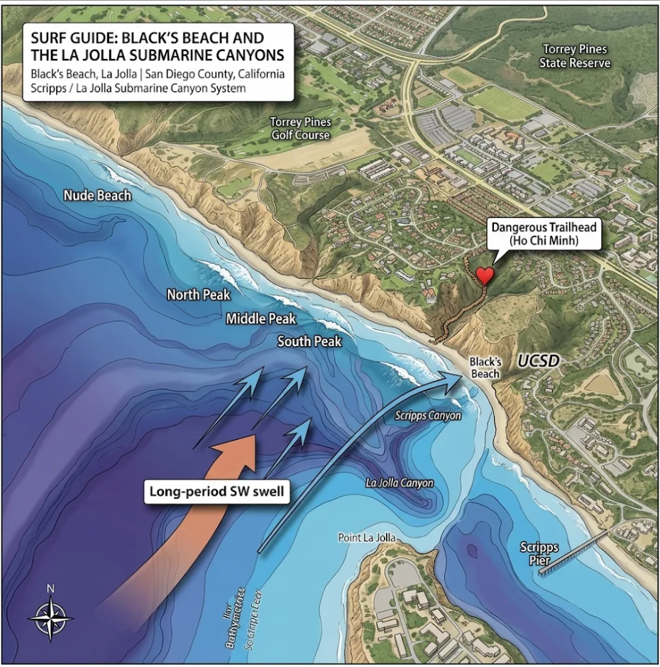
    Illustrated surf map of Black’s Beach, La Jolla: North, Middle and South Peaks, with Scripps Canyon and La Jolla Canyon offshore bending long-period SW swell toward the beach
    Black’s Beach and the La Jolla submarine canyons: the deep Scripps and La Jolla canyons bend incoming long-period swell, focusing energy toward Black’s North, Middle and South Peaks.

    The Canyon: An Underwater Wave Machine

    Scripps Submarine Canyon creates a dramatic change in ocean depth just offshore. The canyon has steep underwater walls, deep channels and surrounding areas of considerably shallower continental shelf.

    When incoming Pacific swell encounters this underwater landscape, something fascinating happens.

    Waves travel at different speeds depending on water depth. Over the deep canyon, waves can travel faster than they do over the surrounding shallow seabed. This difference in speed causes incoming wave crests to bend, a process known as wave refraction.

    Imagine a straight line of incoming swell approaching an underwater valley. The portion of the wave traveling over the deeper canyon advances faster, while the portions traveling over shallower ground slow down.

    The result is a bending and redistribution of wave energy.

    It’s almost as if the ocean floor is reshaping the swell before it ever reaches the beach.

    Why Black’s Can Get Bigger Than Its Neighbors

    Here’s where things get particularly interesting.

    The Scripps Canyon system can create areas where incoming wave energy converges and other areas where it spreads apart.

    Research around the canyon has demonstrated that wave energy can become focused toward the northern side of the canyon, near Black’s Beach, while areas farther south can experience reduced wave energy.

    This process helps explain why Black’s can receive powerful, concentrated swell while nearby stretches of coastline experience noticeably different conditions.

    It’s important to understand that the canyon doesn’t automatically make every wave bigger. It redistributes incoming energy, creating localized areas of focusing and wave-energy shadowing.

    Under the right swell direction and period, that focusing can contribute to some seriously impressive surf.

    The Power of Long-Period Groundswell

    Not all swell interacts with the canyon in the same way.

    Long-period groundswell is particularly interesting because its energy can begin interacting with the ocean floor farther offshore.

    As these waves approach the continental shelf, the changing depths influence their speed and direction. The canyon’s underwater walls can therefore play a significant role in how the swell is refracted and distributed.

    Research around Scripps Canyon has identified particularly strong refraction effects for certain longer-period swell conditions.

    For Black’s, this makes swell direction and period just as important as the forecast wave height.

    A powerful northwest groundswell can interact with the canyon differently than a shorter-period wind swell or a swell arriving from another direction.

    It’s one reason why watching the offshore forecast alone doesn’t always tell the whole story.

    The Other Side of the Canyon: Currents and Rips

    The underwater geography doesn’t just influence wave size. It also contributes to the complicated water movement around Black’s.

    Differences in breaking-wave energy can create variations in water levels and circulation patterns along the beach.

    Combined with the canyon, shifting sandbars and shoreline shape, these processes can contribute to:

    • Powerful alongshore currents
    • Localized rip currents
    • Changes in where waves break
    • Areas of concentrated water movement
    • Dramatically different conditions between neighboring peaks

    This is part of what makes Black’s such a challenging surf environment. The same underwater geography that helps shape its waves also contributes to the complexity of the lineup.

    The SHOREY™ Take: The Ocean Floor Is Part of the Break

    Black’s Beach isn’t simply a beach that happens to receive powerful Pacific swell.

    It’s a fascinating example of how underwater geology, ocean depth and wave physics work together to shape a surf break.

    The Scripps Submarine Canyon acts as a natural wave-energy redistributor. Its deep channels and steep underwater slopes influence how incoming swell travels toward the coastline, creating areas of convergence and divergence.

    That means two beaches relatively close together can experience dramatically different surf conditions under the same offshore swell.

    For surfers, it’s a reminder that there’s a whole world beneath the surface influencing what happens above it.

    The wave starts forming long before it reaches the sand.


    SHOREY™

    For the love of waves, shorebreak, and everything in between.

    Respect the ocean. Understand the break. Ride what the ocean gives you.

    Cover photo: Alex Beattie on Unsplash

  • Winter Is Delivering: Quality Swell Keeps Rolling Into Victoria

    Winter Is Delivering: Quality Swell Keeps Rolling Into Victoria

    Southern Ocean systems continue to fuel the Surf Coast, with another promising stretch of winter waves on the horizon.

    SHOREY™ | Surf Outlook · July 29, 2026

    Victoria’s Surf Coast is right in the middle of its winter rhythm, and the Southern Ocean continues to provide plenty of reasons to keep the surfboard close.

    Powerful weather systems tracking across the Southern Ocean are generating consistent swell, keeping exposed breaks active and setting up opportunities for quality winter sessions. With more energy expected to move toward the coastline, surfers will be watching closely for the combination of swell direction, favorable winds, and the right tide.

    Winter is when the Southern Ocean shows its strength. The challenge is knowing when and where to find the best conditions.

    The Southern Ocean Keeps Delivering

    Victoria’s winter surf is heavily influenced by low-pressure systems moving through the Southern Ocean. These systems generate powerful waves that travel thousands of kilometres before reaching Australia’s southern coastline.

    The result is a steady supply of swell energy, although not every pulse produces clean surf.

    As weather systems pass through, conditions can change quickly. Strong winds may create messy surf at exposed beaches, while sheltered locations can offer more protection. Between systems, brief windows of lighter winds can transform the coastline, producing cleaner faces and more organized waves.

    For surfers willing to watch the forecast and move with the conditions, winter can deliver some of the year’s most rewarding sessions.

    Where to Find the Waves

    Victoria’s Surf Coast offers an impressive variety of breaks, from exposed beachbreaks to sheltered reefs and points.

    Exposed locations are generally better positioned to receive the full force of incoming Southern Ocean swell. These breaks can offer powerful waves when the direction and period line up, but they can also become challenging when strong onshore winds accompany the swell.

    More sheltered breaks may provide cleaner conditions when the coastline is exposed to unfavorable weather. The trade-off is often reduced swell size.

    The key is understanding how each break responds to the incoming swell direction.

    A large swell on the charts does not necessarily mean every location will be firing. Local geography, coastline orientation, underwater structure, and wind exposure all determine what ultimately reaches the lineup.

    Watch the Wind Window

    During winter, wind can be just as important as swell size.

    A powerful swell combined with strong onshore winds can produce disorganized surf, difficult paddling conditions, and unpredictable waves. But when the wind eases or turns offshore, the same swell can become a completely different proposition.

    Early morning sessions are often worth watching, particularly when overnight conditions remain calm.

    The best opportunities may come during the transition between passing weather systems, when swell energy remains in the water but winds temporarily become more favorable.

    Those are the windows surfers should be looking for.

    The SHOREY™ Trifecta

    At SHOREY™, we believe finding quality surf comes down to three essential ingredients. We call it THE SHOREY™ TRIFECTA.

    1. Perfect wind direction

    The right wind direction can transform a wave. Light offshore winds help groom the face, while strong onshore winds can quickly disrupt an otherwise promising swell.

    2. The right tide

    Tide influences how waves interact with reefs, sandbars, and shallow-water contours. Some breaks work better with more water over the reef, while others need a lower tide to produce the desired shape.

    3. The right swell — size and direction

    Swell size provides the energy, but direction determines where that energy goes. Period also plays an important role in how much power reaches the coastline.

    When all three elements come together, the conditions can be exceptional.

    That’s the Trifecta.

    What’s Ahead?

    With winter still in full swing, Victoria’s Surf Coast remains in a favorable seasonal position for continued Southern Ocean swell.

    The coming days will be about tracking individual swell pulses and identifying the best breaks as the wind and tide change. Some locations may see powerful surf, while others could offer more manageable conditions depending on their exposure.

    Surfers should keep an eye on updated forecasts, particularly wind changes and incoming swell direction. Conditions can shift quickly during active winter weather, and large surf can bring strong currents, difficult paddle-outs, and hazardous shorebreak.

    The best session may not necessarily be the biggest day. Sometimes it’s the morning when the wind finally turns, the tide reaches the right level, and the swell finds its way into the perfect stretch of coastline.

    Winter Is Far From Over

    Victoria’s Surf Coast has plenty more winter ahead, and the Southern Ocean is showing no signs of running out of energy.

    For surfers, that means more opportunities to chase quality waves, explore different breaks, and make the most of the season.

    Keep watching the swell charts. Pay attention to the wind. Know your local break.

    And when the Trifecta comes together, be ready.


    SHOREY™

    For the love of waves, shorebreak, and everything in between.

    Respect the ocean. Understand the break. Ride what the ocean gives you.

    Cover photo: Stephen Tafra on Unsplash

  • Skeleton Bay: Chasing the World’s Ultimate Desert Barrel

    Skeleton Bay: Chasing the World’s Ultimate Desert Barrel

    A remote stretch of Namibian coastline, a powerful Atlantic swell, and one of the longest, hollowest left-hand barrels on the planet. Welcome to the ultimate surf pilgrimage.

    SHOREY™ | Surf Travel Feature · Namibia, Africa

    There are surf trips, there are bucket-list surf trips, and then there is Skeleton Bay.

    Imagine driving across an endless desert landscape, with towering sand dunes on one side and the cold Atlantic Ocean on the other. Somewhere along this remote coastline, when the swell, wind and sandbank align, one of the most extraordinary waves on Earth comes to life.

    A long, fast, hollow left-hand barrel that seems to go on forever.

    Welcome to Skeleton Bay, Namibia.

    This isn’t your typical tropical surf destination. There are no beachfront resorts, no crowded boardwalks and no warm-water sessions in boardshorts. This is a remote desert surf mission where the journey is part of the adventure and the reward can be one of the longest barrel rides in surfing.

    For anyone who lives for heavy waves, this is about as good as a surf pilgrimage gets.

    Where in the World Is Skeleton Bay?

    Skeleton Bay, also known as Donkey Bay, is located near Pelican Point, just outside Walvis Bay on Namibia’s Atlantic coastline.

    The wave breaks along a shifting sand spit, where powerful Atlantic swell wraps around the point and races down the beach.

    The setting is almost surreal. On one side, the cold Atlantic Ocean. On the other, the immense Namib Desert.

    It’s a landscape that feels like another planet, and its remote location is part of what makes this destination so special.

    The Wave: A Barrel That Just Keeps Going

    Let’s talk about the reason surfers travel halfway around the world.

    Skeleton Bay is a world-famous left-hand sand-bottom point that can produce extraordinarily long, hollow rides. On exceptional days, waves have been reported running well over a kilometre, with some estimates approaching two kilometres.

    Think multiple barrel sections, incredibly fast walls and a current that can carry you down the point in a hurry.

    The wave isn’t simply long. It’s technically demanding.

    The takeoff can be critical, the barrel can become extremely shallow, and the current makes positioning difficult. Miss the opportunity and you could find yourself paddling hard or walking a long way back up the beach.

    This is not a beginner’s wave. It demands serious experience, confidence in heavy water and the ability to handle powerful, hollow surf.

    Skeleton Bay rewards surfers who know exactly what they’re doing.

    When Should You Go?

    Timing is everything.

    The main surf window generally falls during the Southern Hemisphere winter, approximately May through September, with June, July and August often regarded as prime months.

    During this period, powerful Southern Ocean weather systems generate long-period south and southwest groundswell that travels north toward Namibia.

    But there’s a catch.

    Skeleton Bay is notoriously fickle. You can spend a week in Namibia and never see the wave at its absolute best. Then a particular swell arrives, the wind cooperates, and suddenly the desert coastline becomes one of the most exciting places in surfing.

    The key ingredients:

    • Swell: Powerful, long-period south-to-southwest groundswell.
    • Wind: Easterly to southeasterly winds are generally favorable offshore directions.
    • Tide: The changing sandbank and tidal conditions influence how the wave breaks.
    • Timing: The best sessions depend on the precise alignment of swell, wind and bank.

    Don’t book a short weekend and expect Skeleton Bay to deliver. Give yourself a proper window and enough flexibility to move when the forecast comes together.

    Getting There: The Desert Surf Mission

    Getting to Skeleton Bay is part of the adventure.

    Most international visitors connect through Windhoek or arrange flights into Walvis Bay, depending on their travel route and airline availability.

    Walvis Bay is a practical base for reaching the surf area. Swakopmund, farther north, is another popular option, offering more restaurants, accommodation and tourism activities.

    The final approach is where things get interesting.

    Skeleton Bay is reached through remote coastal terrain, and access can involve driving across sand and salt flats. A suitable 4×4 and knowledge of the route are essential.

    Our recommendation? Use a local surf guide.

    A guide can help you understand the swell window, navigate desert access tracks, arrange transportation and stay within permitted access areas.

    Don’t assume every track is open for unrestricted off-road driving. Check current Dorob National Park requirements and permitted access routes before heading out.

    What to Pack: This Is Not a Tropical Surf Trip

    One of the biggest surprises for first-time visitors is the water temperature.

    Namibia’s coastline is influenced by the cold Benguela Current, which brings chilly water and contributes to the region’s famous coastal fog.

    Forget the boardshorts.

    For the winter surf season, plan around a good-quality cold-water wetsuit. A 4/3 mm suit is a useful starting point, with boots and potentially a hood depending on your cold tolerance and the conditions.

    Your travel checklist should include:

    • A quality cold-water wetsuit
    • Surf boots
    • Multiple leashes
    • Extra boards or a reliable repair plan
    • Cold-water surf wax
    • First-aid supplies
    • Plenty of drinking water and food
    • Reliable navigation and emergency communication
    • Comprehensive travel and surf insurance

    Remote surf locations demand preparation. There is no convenient surf shop around the corner when something breaks.

    Where to Stay: Walvis Bay or Swakopmund?

    If the primary mission is Skeleton Bay, Walvis Bay makes logistical sense.

    It’s a practical base for accessing the surf area, with accommodation, restaurants and essential services nearby.

    If you want a broader Namibian coastal experience, Swakopmund is an excellent alternative. It’s a lively seaside town with a strong tourism scene, restaurants, outdoor adventures and plenty to explore between sessions.

    Either way, don’t build the entire trip around one wave. Skeleton Bay may not cooperate every day, so having other activities and surf options makes the journey much more enjoyable.

    When the Surf Is Flat: Explore Namibia

    This is where the trip becomes something bigger than surfing.

    Namibia has some of the most remarkable desert landscapes in the world.

    Sandwich Harbour

    A spectacular meeting of enormous dunes and the Atlantic Ocean. Guided 4×4 excursions offer an unforgettable look at this dramatic coastal landscape.

    Cape Cross Seal Reserve

    Home to a huge Cape fur seal colony along the Skeleton Coast. It’s an incredible wildlife experience, although the smell is something you’ll remember!

    Sossusvlei and Deadvlei

    If you have time to travel inland, the towering red dunes and white clay pans are among Namibia’s most iconic landscapes.

    Swakopmund

    Spend a day exploring the coastal town, enjoying local restaurants, checking out the surf scene and recovering before the next swell arrives.

    The SHOREY™ Trifecta: The Reason You Came

    Skeleton Bay is the ultimate reminder that the best waves are about more than just swell size.

    You can have a massive swell and still miss the magic. You can have offshore winds and no decent bank. You can have the perfect tide and the wrong swell direction.

    At SHOREY™, we call it THE SHOREY™ TRIFECTA:

    1. The perfect wind direction

    Offshore conditions that groom the wave and keep the barrel clean.

    2. The right tide

    The tidal stage that works with the shifting sandbank.

    3. The right swell

    The correct size, period and direction to bring the wave to life.

    When those three ingredients come together, Skeleton Bay can produce the kind of waves that make surfers book flights from the other side of the planet.

    And when they don’t? You still get the Namib Desert, the Atlantic Ocean and an adventure that very few surf destinations can match.

    The SHOREY™ Verdict

    Skeleton Bay isn’t for everyone.

    It’s remote, cold, unpredictable and technically demanding. It doesn’t offer the convenience of a tropical surf resort or guarantee a perfect wave every morning.

    But for experienced surfers who live for long, hollow barrels, it represents something special.

    A desert coastline. A powerful Atlantic swell. A shifting sandbank. And the possibility of a ride that seems to go on forever.

    This is one of those places where the journey is just as memorable as the wave.

    Put Skeleton Bay on the list. Watch the forecast. Find the window. Chase the swell.


    SHOREY™

    For the love of waves, shorebreak, and everything in between.

    Respect the ocean. Understand the break. Ride what the ocean gives you.

    Cover photo: Luis Santiago on Unsplash

  • East Coast Winter Surf Outlook: Tropical Swells Fade as Southern Energy Takes Over

    East Coast Winter Surf Outlook: Tropical Swells Fade as Southern Energy Takes Over

    Queensland and Northern NSW enter a quieter stretch, while Central and Southern NSW look toward a modest increase in winter southerly swell.

    SHOREY™ | Surf Forecast · June 30, 2026

    Australia’s East Coast is entering a different phase of the winter surf season. The tropical swell activity that brought some welcome waves to the region earlier in June is beginning to fade, leaving surfers looking toward the Southern Ocean and Tasman Sea for the next opportunities.

    The latest seasonal outlook suggests a relatively quiet period for Queensland and Northern NSW, while Central and Southern NSW could see a slight increase in longer-period southerly swell as winter weather systems become the more influential source of wave energy.

    It’s a changing pattern rather than a major coast-wide swell event. The best opportunities will depend on local exposure, passing weather systems, and finding the right wind and tide.

    The Big Picture: A Change in Swell Sources

    The middle of June brought a late-season tropical swell run to Australia’s East Coast, followed by a larger southerly swell. Outside those events, much of the coastline had experienced relatively quiet surf.

    That pattern is expected to continue as tropical swell sources become less influential.

    According to Surfline’s June 27 Australia and New Zealand winter outlook, the focus is shifting toward stronger Southern Ocean and mid-latitude weather influences. This generally favors Australia’s southern states, while reducing the likelihood of consistent east-facing swell along Queensland and northern NSW.

    For surfers, the message is straightforward: the reliable tropical energy is winding down, and the winter surf season is becoming increasingly dependent on individual weather systems.

    Queensland: A Quieter Winter Pattern

    Queensland is entering a period when consistent surf becomes harder to find.

    The Gold Coast and Sunshine Coast typically benefit from easterly and southeasterly swell generated by tropical and subtropical weather systems. As those sources become less active, the region can experience longer stretches of smaller surf.

    Southerly swell can still reach exposed locations, but the coastline’s orientation and offshore geography limit how much energy makes it into many breaks.

    The seasonal outlook suggests Queensland could experience slightly below-average swell through the remainder of winter.

    Surfers should remain alert for occasional changes in the Tasman Sea, but there is no basis for calling a major easterly swell event at this stage.

    Northern NSW: Waiting for the Next Pulse

    Northern NSW is facing a similar pattern.

    The tropical swell that helped provide some activity in mid-June is expected to become less reliable. Beaches and points that depend on easterly energy may experience longer periods between worthwhile swells.

    There is still potential for individual southerly pulses and local weather systems to improve conditions, but the broader outlook points toward a quieter-than-average period.

    For surfers, this is a time to watch the smaller details: local wind changes, passing fronts, and the occasional swell that finds its way into exposed locations.

    Central NSW: A Modest Winter Boost

    Central NSW is better positioned to benefit from the changing swell pattern.

    As longer-period southerly energy becomes more influential, exposed beaches and breaks with a southerly aspect could see a modest improvement in surf size.

    The seasonal outlook suggests Central NSW should remain relatively close to average overall, with individual south swell events providing the better opportunities.

    The key will be swell direction. A south swell can produce very different results from one beach to the next, depending on coastal orientation and protection from surrounding headlands.

    Southern NSW: Keep an Eye on the South

    Southern NSW is also positioned to benefit from the increase in longer-period southerly swell.

    Exposed beaches and breaks that receive direct southern energy will be the locations to watch when the next suitable system develops.

    However, a bigger swell does not automatically mean better surf. Strong winds associated with passing weather systems can create messy conditions, powerful currents, and difficult paddle-outs.

    The best sessions may come after the weather has moved through, when the swell remains but winds begin to ease.

    The Tasman Sea: A Developing Weather Story

    There is another reason to keep an eye on the East Coast forecast.

    On June 30, a coastal trough developed off northern NSW and southeastern Queensland. According to the Bureau of Meteorology’s historical records, the trough subsequently moved south and intensified into a low-pressure system off the Illawarra coast on July 1.

    That development brought several days of significant weather to parts of the east coast, including heavy rainfall and damaging wind gusts.

    While this was not something that could be treated as a confirmed major surf event in the June 30 outlook, it demonstrates why the Tasman Sea remains an important area to monitor.

    East Coast lows and coastal troughs can generate substantial wind and wave activity, but their surf impact depends on their position, movement, strength, and the direction in which their winds blow across the water.

    For surfers, these systems can bring opportunities, but they can also produce dangerous coastal conditions.

    El Niño: The Bigger Climate Picture

    El Niño was officially underway by June 30, 2026.

    The Bureau of Meteorology reported that the relative Niño 3.4 index had reached +1.24°C for the week ending June 28, well above the El Niño threshold.

    The Southern Annular Mode (SAM) was also strongly positive, with the daily index reaching +5.03 on June 27. This indicated a significant southward displacement of the belt of Southern Hemisphere weather systems.

    These climate drivers help explain the broader seasonal pattern, but they do not provide a direct surf forecast.

    Surfline’s winter outlook suggested that El Niño could contribute to stronger Southern Ocean activity and quieter conditions across tropical and subtropical swell regions. It also emphasized that other climate drivers and natural weather variability play important roles.

    In other words, El Niño provides background context. The actual waves still depend on the storms that develop and where they travel.

    The SHOREY™ Trifecta

    With a quieter East Coast swell pattern, timing becomes even more important.

    At SHOREY™, we look for three essential ingredients:

    1. Perfect wind direction

    Light offshore winds can transform an average swell into a clean, organized session. Watch for opportunities between passing weather systems when winds ease or become favorable.

    2. The right tide

    The tide changes how waves interact with beaches, reefs, points, and sandbars. The ideal window varies from break to break.

    3. The right swell — size and direction

    As tropical swell fades, southerly energy becomes increasingly important for Central and Southern NSW. Finding the right exposure will determine which breaks benefit most.

    When all three line up, that’s the SHOREY™ TRIFECTA.

    The SHOREY™ Verdict

    June 30 marks a transition in Australia’s East Coast winter surf season.

    The tropical swell run that brought some activity earlier in June is fading, and the broader outlook points toward quieter conditions across Queensland and Northern NSW.

    Central and Southern NSW are better positioned for a modest increase in longer-period southerly energy, although the seasonal outlook does not support calling a major coast-wide swell event.

    The developing coastal trough off northern NSW and southeastern Queensland also serves as a reminder that the Tasman Sea can change the forecast quickly.

    For now, keep expectations realistic, watch the southern systems, and pay attention to local conditions.

    The waves may not be arriving every day, but winter still has opportunities for those willing to find them.


    SHOREY™

    For the love of waves, shorebreak, and everything in between.

    Respect the ocean. Understand the break. Ride what the ocean gives you.

    Cover photo: Kazuhisa Sadogawa on Unsplash